Latest PIE
![]()
Click image for full listing...
PIE Limerick Discussion: International Trends in Learning Cities read...
Cities Learning Together - 11th PASCAL International Observatory Conference - Hong Kong 18-20 November 2013 read...
Call for Contributions - Cities Learning Together - 11th PASCAL International Observatory Conference read...
Development of a Network of Learning Cities & the Learning Cities Index - Dumfries, March 27, 2013 read...
Strathclyde University Discussion - Cities East and West read...
Latest News
Celebrating Learning in Brimbank
read...
Covid Education Alliance (COVIDEA): Adapting education systems to a fast changing and increasingly digital world through the use of appropriate technologies
read...
17th PASCAL conference, July 4th to 6th, 2024 - New Challenges for Higher Education, Cities and Regions: Addressing the United Nations’ Sustainable Development Goals (SDGs), in Changing Contexts – Revised Dates for Abstracts
read...
Upcoming Events
04-07-24
Conference Announcement | New Challenges for Higher Education, Cities and Regions: Addressing SDGs in Changing Contexts - Taipei, July 4-6, 2024
read...
27-11-24
Scottish Educational Research Association (SERA) - 'Education in a Fragile World: Past, Present, Future' at the University of Dundee from the 27-29 November 2024
read...
Follow us on:
Shortlink
Streets, publicness and the public realm | JOHN TIBBITT from Policies for Places
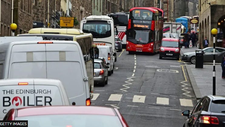
The City of Edinburgh has just announced the beginning of a 3-month consultation on its new transportation plan to help the city achieve its zero-carbon target by 2030. The transport convenor hopes the consultation will reach every ‘nook and cranny’ of the city to hear people’s views and further refine the proposals. The city is one of the most congested in the UK. It also has a fast-growing population with land set aside for an additional 37000 homes. If current transportation patterns continue mobility problems for residents, businesses and visitors can only get worse.

Edinburgh’s problems are by no means unique. Nor are the priorities identified for attention in the plan. Council plans focus on active travel, pedestrians and parking all with the aim of increasing public transport capacity, efficiency and reliability. As the City transport convenor put it ‘if we can get people out of their cars public transport is there for the heavy lifting’.
The plan is part of a long-term transition for the city over the next ten years. The plan envisages many streets in the city centre being closed to traffic and pedestrianized, substantial investment in transport infrastructure, cars routed around the city centre, new major routes for walking and cycling, and a new bus strategy for reduced journey times and improved efficiency and regularity.
The city has already taken initial steps to improve safety for pedestrians with a ban of pavement parking and the planned introduction of an ultra-low emission zone (ULEZ) to exclude the most polluting vehicles from the centre of the city. Controlled Parking Zones (CPZ) are spreading to more areas and Low Traffic Zones (LTZ) are planned in some neighbourhoods.
Transforming the role of the street
The transition envisaged in Edinburgh’s city transportation plan, although it is predicated on boosting the capacity of public transport and active travel alternatives in order to facilitate a reduced need for car journeys will also have major impacts on public health, pollution and the environment. It also has huge implications for the lived experience of people in the city through fundamental changes to the role of its streets, from iconic historical streets such as the Royal Mile and the Old Town to main thoroughfares, neighbourhood main streets and in residential areas.
Edinburgh is joining a general trend in European cities and elsewhere to revise the role of its streets. Arguably, streets are the most important places in a city, and they should be a primary concern. They constitute the most fundamental element in a city’s infrastructure. Historically they have been the key arteries permitting mobility, exchange of goods and commerce, and social interaction. Streets are the arenas in which social and economic life is played out. During the last century, streets have been engineered to promote efficient vehicular movement and the transportation of goods, often to the detriment of the quality of life available to other users of the street and to any sense of community and place identity.
Road engineers and urban planners can often seem to be seeking incompatible objectives. Roads are widened, designs are modified, junctions re-configured, or bypasses are built to speed up traffic, reduce congestion and generally make it easier to get into or out of towns and cities, often with scant regard for streets as part of the public realm and so essential for sustaining the variety of activities which characterize the vitality of city life.
Street as critical assets
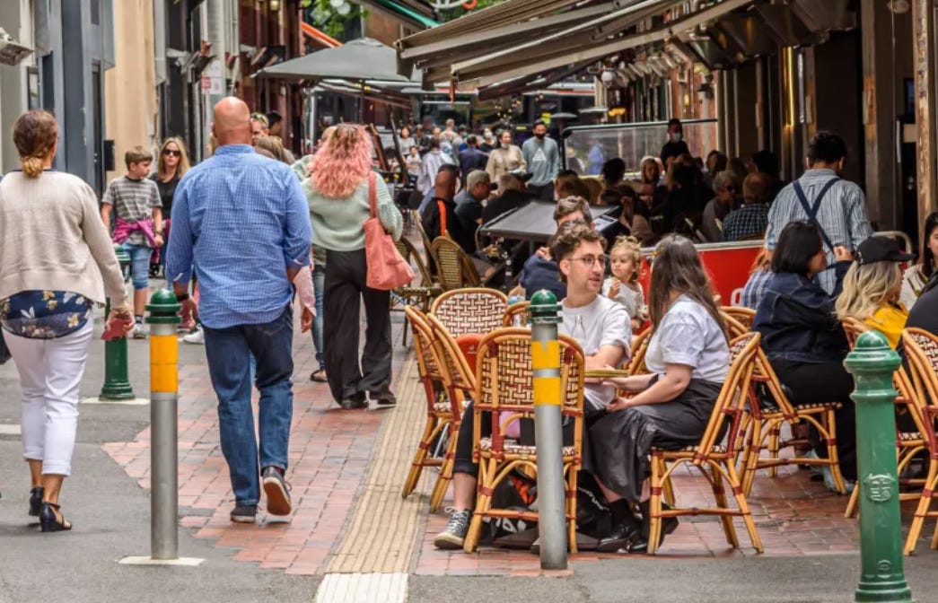
It seems we often forget that streets are essential for both access and place. Urban planners and urban designers, through schemes such as that proposed in Edinburgh, are seeking to reclaim streets as a city asset with these dual roles. Cities’ initiatives were given a boost from experience during the pandemic as local living led authorities to reassess the value of streets and public spaces within the public realm. Whilst decisions taken during the pandemic are being reversed in many cities, the need for bold strategies preserving the use of public spaces is stronger than ever. Public spaces and places are an important key for cities in their struggle for post-pandemic recovery. Streets are fundamental to cities’ infrastructure and comprise a large proportion of the public realm. Street patterns and urban design play crucial roles in shaping sustainable and liveable environments while also enhancing urban mobility and walkability.
The Edinburgh planning initiative described earlier should be seen in this context. Some other European capitals also provide bold examples of this kind of transformation. Paris, already pursuing the 15-minute city concept, (see my previous posts on the 15-minute city), has been progressively removing cars from more and more streets, starting with ‘car-free’ Sundays when city centre streets are handed over to cyclists and pedestrians. Plans are being accelerated following the Olympic Games to be held in the city later this year as the Mayor seeks the move the city away from the car.
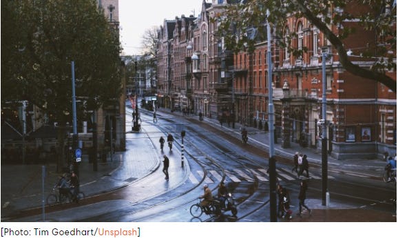
Amsterdam has a 27-point car free agenda which will drastically reduce traffic in a city which is already known for promoting active travel. It is removing some 11000 parking spaces, narrowing streets and using the space for wider pavements, trees, bike lanes and bike parking,
These changes lower carbon emissions and energy consumption while increasing accessibility to essential services and amenities. Incorporating green infrastructure, such as street trees, rain gardens, and pedestrian-friendly amenities, wider pavements and bike lanes help create new streetscapes and improve overall urban aesthetics.
The ‘publicness’ of the public realm
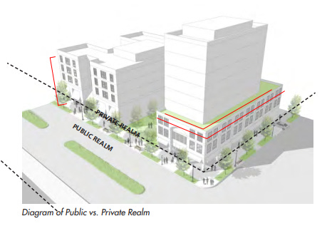
The public realm is not always public. It has two inter-related components. The “public realm” consists primarily of the publicly-owned thoroughfares and streets, pathways and rights-of-way and other publicly accessible open spaces such as parks, squares, plazas, and courtyards. The “private realm” consists of privately-owned areas often in large developments but with more limited accessibility to the public. Examples would include shopping malls, residential developments or a variety of so-called third places. (I have written about third places here).
The typical division of the two sectors is neatly illustrated in this drawing taken from a San Diego planning document.
The publicness of a public space can be defined as the sum of all those characteristics that make a public space public. Publicness arises through the interaction of a range of factors which include ownership, accessibility and communication and interaction between people. These factors will be influenced by physical form, mechanisms for control, and the activities and events permitted. Publicness is multi-dimensional and a relative concept as for any public place there will be attributes that are more public than others.
Streets and ‘publicness’
The developments in city centres I have described above show that streets are increasingly seen as the quintessential centre of public life, open, accessible and places of unplanned social contact and recreation. The efforts to reduce motor traffic and re-allocate street space are intended to make streets more inclusive and less the preserve of the vehicle owner.
Streets probably comprise the largest part of the public realm in most towns and cities, and are typically seen as part of the ‘public’ public realm. However, modern development trends suggest that the public and private realms are becoming increasingly intertwined and boundaries between them more problematic. So far as streets are concerned, the politics and economics of public and private space highlight the importance of issues such as the rules for access, the source and nature of control over entry, the individual and collective behaviour allowed in specific spaces, and the rules of use.
Issues such as these are key in influencing the publicness of the public realm in general and streets in particular. Ownership is becoming increasingly blurred, driven in part by limitations in public finance and the growing recognition by private developers of the added value to their developments from a degree of public access and from entertainment or cultural events.
The diagram below provides a simple model to illustrate options for the publicness of the public realm, and it is interesting to locate the development of streets within it.
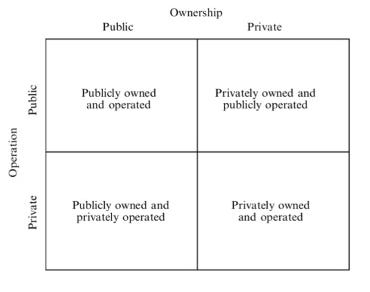
It can be argued that the top-left hand square offers the highest level of publicness, and publicness decreases as one moves to the lower-right square. It is interesting to locate different kinds of street on this grid. I suspect it would be possible to find streets which could be placed in each of the cells. Main through routes would be in the top lest box. Pedestrianized retail streets could be in any box and depend for their success on co-operation between public authorities and private retailers and other service providers. Residential streets vary from wide public boulevards to private, sometimes gated, roads to exclusive housing developments. Alley ways and back streets in commercial or residential areas often a mix of public and private stakeholders.
The transformation of streets in my examples above would, on the face of it, represent an enhanced publicness for the re-imagined city streets and the public realm. The implementation, rule-making and control of car-free or reduced-traffic streets usually lies with public authorities. But even here many of the features which give streets vitality – cafes, pop-up markets, street entertainers, outdoor cultural events and the like – depend on the incorporation and co-operation of private initiatives. A challenge for those re-imagining the contribution of streets to the publicness of the public realm is to embrace the wider influence of local communities and community groups and avoid handing too much influence and control to private interests.
Further reading
Li,J, Dang, A, Song, Y (2022): Defining the Ideal Public Space: a Perspective from Publicness, Journal of Urban Management, 11,6, ps 479-487.
Varna, G.M (2011): Assessing the Publicness of Public Spaces: Towards a New Model, PhD thesis, University of Glasgow
Source: Substack
 Printer-friendly version
- Login to post comments
Click the image to visit site

Click the image to visit site

Click the image to visit site

Click the image to visit site

Click the image to visit site